
Imagine standing in the middle of the Atacama Desert, the driest place on Earth, staring at a turquoise lagoon hidden between salt flats and volcanoes. That’s the magic of exploring with an Atacama Desert map, and I’m so thrilled to share this with you! With free printable maps and GPS coordinates, you can find hidden gems like the Baltinache and Cejar Lagoons without getting lost. This guide comes straight from my heart because I want you to feel the wonder of this desert, perfect for adventurers from the US and UK.
Why the Atacama Desert Is a Must-Visit
The Atacama Desert in northern Chile stretches over 1,000 miles along the Pacific coast, tucked between the Andes and Coastal Range mountains. It’s known for its Mars-like landscapes, with vast salt flats, colorful geysers, and starry skies perfect for stargazing. What makes it extra special are the hidden lagoons—sparkling pools of water that seem like miracles in this dry land. Tripadvisor reviews call it “a surreal adventure,” with one visitor saying, “The lagoons feel like secret oases in a moonscape!”
The desert’s unique vibe comes from its extreme dryness—some areas get less than 1mm of rain a year! Yet, you’ll find flamingos at Laguna Chaxa and swim in salty Cejar Lagoon, like floating in the Dead Sea. With a good map and GPS coordinates, you can explore these spots easily, even if you’re not a pro navigator. A free printable map makes it simple to plan your route and discover the Atacama’s beauty.
Where to Find Hidden Lagoons
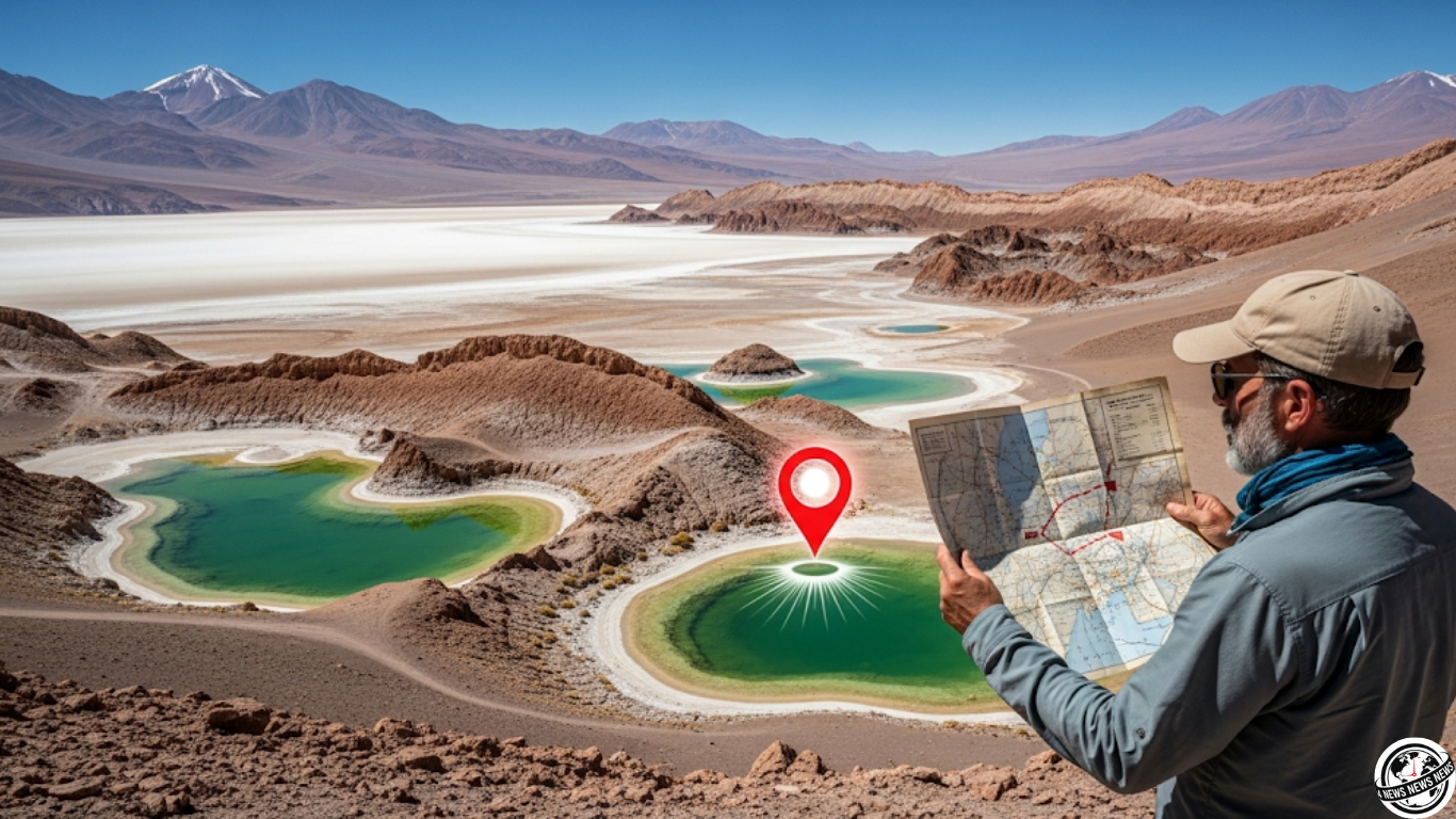
The Atacama’s hidden lagoons are the stars of the show. Baltinache Lagoons (23°55’45”S, 68°14’20”W) are a cluster of seven salt pools, some swimmable, hidden 45km from San Pedro de Atacama. The bumpy dirt road takes effort, but the turquoise waters against white salt flats are worth it. Cejar Lagoon (23°03’49”S, 68°13’17”W) is closer to San Pedro, about 20km, and perfect for floating in salty water. Laguna Chaxa (23°17’16”S, 68°10’41”W) in Los Flamencos National Reserve is a flamingo haven, great for photos. These coordinates work on Google Maps or GPS devices.
You can download a free Atacama Desert map from sites like explore-atacama.com or atacamacontact.com, which mark key spots like these lagoons. Print it before you go, as Wi-Fi is spotty in the desert. A Reddit user shared, “Having GPS coordinates for Baltinache saved us hours of driving!” Many maps also show Valle de la Luna and El Tatio Geysers, so you can plan a full day of exploring. Always check road conditions, as some routes are rough and need a 4×4.
How to Get Your Free Map
Getting a free Atacama Desert map is easy! Websites like atacama.explora.com offer downloadable maps with major attractions, including lagoons, marked clearly. Search “Atacama Desert map free download” on Google to find PDFs from trusted sites like thediscoveriesof.com. These maps include GPS coordinates for places like Baltinache (23.9292°S, 68.2389°W) and Cejar (23.0636°S, 68.2214°W). Print a copy at home or save it on your phone for offline use. Some maps, like those from San Pedro’s tourism board, are available at hotels or visitor centers.
For navigation, use apps like Maps.me or Google Maps offline with the coordinates. If you’re joining a tour, guides often provide maps, but having your own ensures you can explore solo. Book tours through GetYourGuide or Viator for about £40, which may include lagoon visits. If driving, rent a 4×4 in San Pedro for £50/day, as roads to Baltinache are tough. Always carry water and snacks, as there are no shops near these remote spots.
Tips for an Amazing Atacama Adventure
To make your trip unforgettable, visit in spring (September-November) or fall (March-May) for mild weather—daytime highs of 25°C (77°F) and cool nights. Pack sunscreen, a hat, and layered clothes, as temperatures drop fast after sunset. Altitude sickness is a concern at lagoons like Baltinache (3,900m), so spend a day acclimating in San Pedro (2,400m) first. A blog on peterorsel.com suggests, “Start with low-altitude spots like Cejar before hitting higher ones.” Bring binoculars for flamingo spotting at Chaxa and a swimsuit for Cejar or Baltinache.
From the US or UK, fly to Santiago, Chile, then take a 2-hour flight to Calama (£80 round-trip on LATAM) and a 1-hour shuttle to San Pedro (£10). Stay in San Pedro at hostels like Hostal Mamatierra (£30/night) or splurge on explora Atacama (£200/night) for guided tours. Pair your lagoon visits with stargazing at Ckamur or a hike in Valle de la Luna for a full desert experience.
Why the Atacama Steals Your Heart
This Atacama Desert map with GPS coordinates is your key to discovering hidden lagoons that feel like secrets only you know. Floating in Cejar, watching flamingos at Chaxa, or marveling at Baltinache’s turquoise pools will make you feel like you’re on another planet. The free printable map makes it easy to explore without stress, leaving you free to soak in the desert’s beauty. Book your trip, print your map, and get ready for an adventure that’ll fill your heart with wonder